Kayaking - Bustard Islands
French River Waterway Provincial Park
Access/Launch:
Key River Marina
north of Key River bridge on hwy 69 north of Pointe au Baril Station (and Parry Sound)
Hartley Bay
on French River, just north of Key R.
Difficulty Level:
Intermediate - advanced (depending on weather)
Length:
3 - 4 days
50 km
Description:
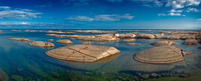
Classic Bay - full of shoals and stunning landscape. The group is made up of about 600 islands, some nothing more than shoals poking above the surface of the water. Worth a couple days' exploration, with many opportunities for side trips.
Much wildlife has been spotted here, including mink, turtles, and heron.
Tanvat Isl. (W 11 km from mainland at the mouth of the Key R.) displays whorl holes on the north side - cylindrical holes carved in the rock by swirling pebbles.
The range towers on Bustard Rocks west of the main island have been there since 1875. Lighthouse keepers used to staff these islands spring, summer, and fall.
These isolated islands are frequently buffeted by high winds causing unfriendly waves. Still, the sheltering islands make exploration within the group possible on days you wouldn't venture elsewhere.
There is some current flowing out the Key River, but if the winds blow their usual westerly force, it is possible to sail back up the
Kayaking - Bustard Islands
Access/Launch:
Key River Marina
north of Key River bridge on hwy 69 north of Pointe au Baril Station (and Parry Sound)
Hartley Bay
on French River, just north of Key R.
Difficulty Level:
Intermediate - advanced(depending on weather)
Length:
3 - 4 days
50 km
Description:
Classic Bay - full of shoals and stunning landscape. The group is made up of about 600 islands, some nothing more than shoals poking above the surface of the water. Worth a couple days' exploration, with many opportunities for side trips.
Much wildlife has been spotted here, including mink, turtles, and heron.
Tanvat Isl. (W 11 km from mainland at the mouth of the Key R.) displays whorl holes on the north side - cylindrical holes carved in the rock by swirling pebbles.
The range towers on Bustard Rocks west of the main island have been there since 1875. Lighthouse keepers used to staff these islands spring, summer, and fall.
These isolated islands are frequently buffeted by high winds causing unfriendly waves. Still, the sheltering islands make exploration within the group possible on days you wouldn't venture elsewhere.
There is some current flowing out the Key River, but if the winds blow their usual westerly force, it is possible to sail back up the channel with a jury-rigged tarp.
Maps/Charts:
Topo - 41 H/15
Marine chart - 2204
NOTE: water level forecasts for July for Lake Huron – Georgian Bay are 0.22m (8.6in) above chart datum, which is the marine chart indicated depth.
Other:
If you plan to paddle the 13 km channel from the marina, spending the previous night at Grundy Provincial Park will let you put in a full day to get out onto the Bay where you can finally camp. The south shore of the Key River chanel is the Henvey Inlet Indian Reserve - there is no camping. Parts of the north shore are crown land, but much of the landscape does not make for easy camping.
First good camp site is on the end of Dokis Isl. or on mainland north of Dead Isl. - about 20 km from the put-in.
Dead Island is a native burial site. Treat is as you would a cemetery. The story is that the graves on this site were raided for the Chicago World's Fair.
Safest approach to the Bustards is north, through the Fox Islands.
West winds can be quite strong here. Anchor your tent well and secure your boats where they won't be blown around.
In windy weather, head north and paddle in the shelter of the Fox Islands.
with a jury-rigged tarp.
Maps/Charts:
Topo - 41 H/15
Marine chart - 2204
NOTE: water level forecasts for July for Lake Huron – Georgian Bay are 0.22m (8.6in) above chart datum, which is the marine chart indicated depth.
Other:
If you plan to paddle the 13 km channel from the marina, spending the previous night at Grundy Provincial Park will let you put in a full day to get out onto the Bay where you can finally camp. The south shore of the Key River chanel is the Henvey Inlet Indian Reserve - there is no camping. Parts of the north shore are crown land, but much of the landscape does not make for easy camping.
First good camp site is on the end of Dokis Isl. or on mainland north of Dead Isl. - about 20 km from the put-in.
Dead Island is a native burial site. Treat is as you would a cemetery. The story is that the graves on this site were raided for the Chicago World's Fair.
Safest approach to the Bustards is north, through the Fox Islands.
West winds can be quite strong here. Anchor your tent well and secure your boats where they won't be blown around.
In windy weather, head north and paddle in the shelter of the Fox Islands.
