Hike - La Cloche Silhouette Trail |
|
|---|---|
| Access | The trail head of the La Cloche Silhouette Trail is located at the main park camp ground at George Lake. |
| Length | 78km |
| Time | 7 - 10 days |
| Difficulty | Portions of the trail are considered difficult due to numerous steep and rocky sections. |
| The trail notes have been broken down into five sections, travelling in a clock-wise fashion. | |
The La Cloche Silhouette trail is Killarney's only backpacking trail. Named after his painting "La Cloche Silhouette" this trail is dedicated to the memory of The Group of Seven artist Franklin Carmichael (1890-1945)
This challenging yet rewarding trail covers a total distance of 78 kilometres; passing over ridges, through valley bottoms and alongside picturesque crystal clear lakes. Due to its length and rugged nature, the trail requires a good level of physical conditioning on part of the hiker, and your hike should be carefully planned. The backpacker should plan on a 7 to 10 day outing. The Trail begins and ends at George Lake, at the Parks Main Entrance, in 78km Loop.
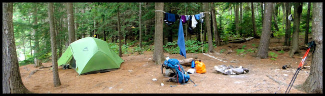
Campsite and Permits: All together there are 54 campsites along the course of the trail. Permits are required for these interior sites and the backpacker must present their planned travel route indicating where they plan to camp each night. Due to the limited number of sites, it is recommended to book early. This can be done using Ontario Parks Central Reservation Number, 1-888-ONT-PARK or 1-888-668-7275.
Self-Guided all inclusive Hiking expeditions
We offer complete multi-day backpacking trip planning and outfitting, we'll take the hassle out of planning a hike. Our convenient and personalized outfitting packages are ideal for those who enjoy self-guided wilderness adventure.
We provide high quality equipment and delicious, healthy, well-balanced wilderness menus. (we know how hungry paddlers get and a group travels on its stomach, 2000 - 3000 calories a day)
Our staff will facilitate and coach you through the entire procedure; initial preparations, route planning and permitting. Ultimately, we will assist you with packing your gear, tips and tricks included. We’ll ensure that you are good to go!
Our all inclusive outfitting package is designed for the first time backpacker wishing to experience a world class trip while utilising the finest equipment, service and food available.
Are you a seasoned adventurer? you will quickly appreciate our experience and proficiency.
See our complete outfitting page: http://www.killarneyoutfitters.com/complete-outfitting.php
Maps: Updated 2001 Killarney Park Maps, complete with location of all interior sites, contour lines and tips for backcountry travel can be purchased at the Sportsman's Inn or from the Friends of Killarney Park at (705) 287-2800 or on-line at www.friendsofkillarneypark.ca
" The main trail at Killarney Provincial Park is a 78 km loop known as the La Cloche Silhouette Trail. In 2004, 3 kms were added around H8, to bypass a bridge. You can travel in either direction around the loop but most backpackers travel in the clockwise direction, as in this photo hike. I believe this to be the best choice for several reasons. From what I have experienced on the screed and talus covered slopes on the north ridges, I would not want to do certain slopes in the counter clockwise direction because of safety considerations". ....Tom Simon
La Cloche Silhouette Trail discription guide
George Lake to Three Narrows
Approximate distance: 13 Kilometres
From the western end of George Lake, the trail winds its way through stands of mixed deciduous and coniferous trees. The first campsites are located at Lumsden Lake, about a half kilometre hike from the trail. The Lakes east ridges offer superb views of the surrounding hills and Georgian Bay. Notice the white quartzite rock. You have now crossed into a geological zone, dating back 2.3 billion years.
From Lumsden to Acid Lake, the trail passes over sections of corduroy road, remnants of bygone logging days. As you leave Acid Lake behind, there is a steady climb over Killarney Ridge. Before you start ascending into the valley, check out the spectacular view north from the open rock, located about 20 metres to the west of the trail.
Located at the valley bottom is meandering Artist Creek. Artist Creek is particularly pretty during July and August when wild flowers such as Pickerel Weed and other aquatic plants choke its waters.
At the 12 kilometre point the trail passes close to eastern end of Baie Fine known as “The Pool”. It is worth the short detour to view this picturesque spot. Owing to its spectacular scenery and remote location, the pool has long been a favourite of American yachtsmen. Just a short distance past the pool is the turn off to Topaz Lake, with its deep blue waters and quartzite rimmed cliffs. The clarity of the water is largely due to the lack of floating organisms and sediments.
The climb between Topaz Lake and Three Narrows is considered to be the steepest in the park. A steep descent brings you out at the Three Narrows dam.
Three Narrows Dam to Moose Pass
Approximate distance: 24 Kilometres
After crossing the dam, which regulates the water levels in the park’s largest lake, the trail to the Bodina Lake portage is relatively flat. There are a number of campsites along the western end of Three Narrows. H19, situated on a peninsula, is particularly appealing for those seeking solitude. The ascent to Moose pass is demanding and special attention should be paid to footing. Impressive views southward are not to be missed.
Moose Pass to Silver Peak
Approximate distance: 28 Kilometres
The climb from Moose Pass stream, through an old growth hemlock stand is steep and the footing can be slippery. The climb is well worth it, as the hiker is rewarded with changing vistas of the surrounding countryside from the ridge tops. Short detours provide access to camping sites on Shiguag and Little Mountain Lake. Come nightfall, don’t be surprised to hear the howls of wolves in this area.
Further along, the trail passes between David and Boundary Lake, providing good views of these scenic lakes. Just to the south lies a side trail to the summit of Silver Peak. This rugged trail is about 2 kilometres long and has some steep sections. At the halfway mark, there is a particularly pretty waterfall, especially during periods of run-off. The 360 degree view from the summit of the area’s tallest peak is not to be missed.
Silver Peak to the Crack
Approximate distance: 20 Kilometres
From Silver Peak, the trail heads in southerly direction, through alternating hemlock and birch forests. Silver and Bunnyrabbit Lakes each have two sites. Passing Bunnylake, the trail becomes increasingly rocky and hilly. Heaven Lake, with its striking setting and impressive views of Kakakise Lake, is one of the highest along the trail.
From Heaven the trail descends to Norway Lake. Take the opportunity to rest here and enjoy this picturesque spot, before starting the strenuous climb along the Killarney Ridge to the Crack.
The Crack to George Lake
Approximate distance: 10 Kilometres
The view from the Crack, provides the hiker with a panoramic view of interior lakes, quartzite ridges and to the open waters of Georgian Bay. Below lies Killarney Lake and just to the west O.S.A. Lake. O.S.A. Lake is dedicated to the Ontario Society of Artists in recognition of their efforts to save the area from being logged. In 1932, Group of Seven Member A.Y. Jackson fought successfully for the creation of a nature preserve here.
The descent from the Crack is rugged and can be difficult, especially when wet. Reaching Kakakise Lake, the trail becomes quite flat. Kakakise marks the meeting point of two geological plates, with granite to the south and quartzite lying to the north.
After crossing the beaver pond at the western end of Kakakise, the trail heads west towards Freeland Lake. Freeland Lake provides a great opportunity to view a variety of wildlife including the resident loons and perhaps larger mammals such as moose. Unlike many of Killarney’s Lakes, the shallow waters of Freeland are extremely productive and teem with life.
The trail continues past Wagon Road Lake and above Little Sheguindah. Little Sheguindah’s waters, with its steep walled pink granite cliffs, average a depth of only 2 metres. The lake’s only campsite is located below at the southern end of the lake. A.Y. Jackson is the last lake before the end of trail and arguably one of its prettiest. The view from the south shore takes in the white quartzite ridges above George Lake which stand in sharp contrast to the pink granite shores of this lake. Take the opportunity to go for a refreshing swim in its inviting waters.
The last kilometre is quite rocky with a short steep descent to George Lake. This marks the end of your journey.
78 km - 7Days
Although:
If you have ever trekked the La Cloche Silhouette Trail, you won’t believe this accomplishment!
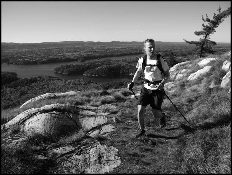
EXTREME HIKING (mountain trail running) Eric Batty La Cloche Silhouette Trail, Killarney Ontario
Saturday, October 9, 2010
Time from Trailhead to Trailhead 12hrs 23mins.
http://ericbatty.blogspot.ca/2010/10/la-cloche-silhouette-trail-visual.html
________________________________________________________________
La Cloche Silhouette Trail - Record - 9hrs 25mins 45sec.
I finished running the La Cloche trail yesterday just before 5pm. For those of you who have hiked the trail, you know how rugged the terrain is. The trail measures 80km in length and just under 8000ft elevation gain/loss. It is one of the hardest trails I have ever done and is probably one of the hardest trails in Eastern Canada!
We drove up Wednesday night making a stop in at to pick up a pair of new kicks to use on the trail. I was previously planning on running it in a pair of New Balance Minimus but after much pondering I decided I needed a last minute switch to something more substantial. I went to to see what they had. I was set on a pair of Salomon's as they fit me well and were the only shoe company that I would toss on strait out of the box and run 80 of the most gruelling km's in. I grabbed a pair of Salomon Crossmax in men's size 9.5... I wore them around the house for a few hours and decided that they were probably going to be to small, especially once my feet start to swell during the run. Size 10 it is.
We arrived in the park just after dark with a full belly of good old Swiss Chalet.. Topped off with a pumpkin spice latte (skinny) from Starbucks. PS. There is now a Starbucks in Parry Sound! We set up camp, packed our packs, made a few last min changes to the set up and hit the hay. It was way too short of a sleep before we woke with sound of the dreaded alarm...5:45am and it was still pitch black out. Gah. We had a slow morning with a relaxed breakfast and two rounds of brew. We would be thankful of that slow, chill morning 8 hrs later.
We set out with a comfortable pace. We were going to be running the trail in a counter clockwise direction and it was going to be wise to get the most technical sections out of the way early on, when the body and mind are still fresh. We made it through the crack in 59mins and felt great! We stopped for about 5secs to check the views and with the next cairn in sight we ran on. We were deciding if we were going to run Silver Peak or not. Silver peak is technically a "side trail" and therefore not part of the trail proper. We hit the cut off for SP at around 2hrs 45min and opted to just put in a good time on the trail without a added difficult section to a already difficult technical trail. We made excellent time from SP through the La Cloche range. We hit the other side of the range at around 6hrs. It was a weird day for weather, as we had rain, sun, hot and cold temps. We were fortunate not to have rain while were running on the compact slippery section of quartzite rock.
With the biggest climbs and most technical sections behind us, we upped the pace a bit as a sub 10hr time was now in sight! We hit campsite H16 at around 7hrs24mins and filled the bottles with water and tossed in some aqua tabs. At this point in the run I was feeling better then I ever have and my running partner Ryan Atkins was feeling the effects of 60km's of one of toughest trails in Canada. We had discussed earlier in the run what to do in the last quarter of the trail if one of us was feeling better then the other. We concluded we would part ways and the one feeling better run ahead and put in the best time that they could. With that in mind, I was feeling good and handed him my cell phone (in case of emergency) and hammered the last 20-22km. I felt great running the last section of the trail. I kept on expecting my body to surprise me, but it just functioned as I had hoped. I had calculated in my head a finishing time of 9hr 33min, but I was very surprised to see the trailhead come so quickly! I had a time on my watch of 9hrs 25min 46sec.
It wasn't even 5pm and in what most peoples day's work timeframe would be, I hammered a 80km trail. So Cool! I then turned my butt around and started back to meet Ryan. There was no celebration at the finish, no banners or crowds of people. It was only a few campers who looked at me very strangely. On the way back to Ryan I decided I would walk and then pace with him back to the finish. I met him shortly after I had a little black bear bluff charge me! He was small and looked like last years cub. He walked out of the forest onto the trail and then ran ten steps towards me and stopped all puffed up. I got into my attack pose and ran at him yelling as loud as I could. He turned and bee lined it through the thick forest. I met up with Ryan and we ran back to the trailhead where we had clean water and towels waiting for us. Ryan crossed the bridge in a time of 10hrs 45mins! It was his first time on the trail and he did amazing! It was my third time running the 80km obstacle course and I knew what to expect. He didn't.
We then hopped in the car and hit the road home. A quick stop in at the restaurant in French River for a burger and fries and with our bellies full we relaxed as the sun dropped and we made our way back towards the suburbia concrete jungle.
Posted by Eric and Eden at 1:37 PM 2 comments